Gentrification, Redlining, Busing, and Race in Upstate New York.

When the disadvantages faced by the African American community in the post-Civil War era in the United States are discussed, they are often framed in the setting of the American South. Segregation, redlining, busing are all issues that plagued the African American community, and has prevented them from creating and building wealth similar to that of white Americans. When these topics are discussed, as little as they may be, they are always framed as a problem only in the deep American South. Northern Americans often times speak about the American South in a condescending tone, arguing that all the issues of race from this country stems from the issues in the American South. However, if you take a closer look into the policies put in place during the 20th century in northern American cities, they are often quite similar to the racist policies that northern Americans are quick to criticize when it comes to the American South. In Upstate New York, which is located about 300+ miles north of the Mason-Dixon Line, redlining, gentrification, and segregation have plagued the small African American communities even up until this day. As of the 2010 census, over 83% of upstater’s are white, and less than 6 percent of the upstate population is made up of black Americans.[1] Nearly all of these African Americans are located in the few cities in the area, and were forced into small segregated neighborhoods. When it comes to racist policies in the United States, the states of the north are just as guilty of holding back African Americans as the states of the south.
The public schools in upstate cities such as Buffalo, Syracuse, and Utica did not desegregate their schools until 1973. Nearly all these cities have schools that are some of the highest segregated in the country. In fact, schools in New York State are even more segregated than schools in the American south. “"In the 30 years I have been researching schools, New York state has consistently been one of the most segregated states in the nation - no Southern state comes close to New York." Gary Orfield, co-director of the Civil Rights Project stated[1]. However, when school segregation is taught in public schools in the United States, it is portrayed as a problem of the past, and one that was only present in southern states. In most cases, the story of the Little Rock Nine is taught as the turning point of racial segregation in United States public schools. It is effectively portrayed that once the National Guard stepped in to desegregate the schools, segregation by skin color in the United States came to an end. But, if you look ahead to 1973, when Upstate cities were instructed to desegregate their schools by local and federal governments, there was an outcry from those who opposed the idea. Although a revisionist historian might try to argue that the opposition to desegregating had nothing to do with race, those in the fight at the time clearly thought differently. Alfredo Slominski, lawyer and former school board member at the time, and a citizen of Buffalo was not afraid to share her thoughts on the topic. “I am opposed to any busing that is done for reasons of racial balance.”[2] It is clear that segregation is still ever present in the United States, and the biggest culprit of it is found in what is viewed as a rather progressive state, New York.
Not only does segregation still plague the African American community in Upstate New York today, other historical racist policies such as redlining hindered the creation of wealth for Upstate African Americans. Redlining is the process of refusing to give someone a loan due to the location of where they live. One of the easiest ways to create wealth in the United States is through the process of buying real estate. During the 20th century, banks and politicians tried to create ways to prevent African Americans from creating and building wealth similar to that of white Americans. The bankers and politicians would divide cities up into three colors, red which was deemed high risk, yellow which was considered medium risk, and blue or green which was considered low risk. The bankers and politicians who created these maps almost always made sure that the red areas were those that predominately African Americans lived in. When African Americans would head to the bank in order to get a loan to purchase a house, they would be denied. With the bank citing the maps provided to them as a reason to not give the loan. These policies were widespread throughout the nation, especially in Upstate New York. In 1938, the federal government provided the banks of Albany New York a redlined map of the city (figure one). The neighborhoods were divided into “best”, “still desirable”, “definitely declining”, and“hazardous” (see figure one).[1]
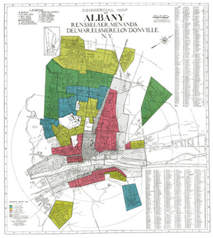
Figure one. “Mapping Inequality.” Digital Scholarship Lab. Accessed December 20, 2021. https://dsl.richmond.edu/panorama/redlining/#loc=12/42.659/-73.849&city=albany-ny.
These were divided clearly by race, as although the black population inside the city was small at the time. When looking at the comments of Home Owners Loan Corp., which is the who was tasked by the federal government to help the redlining of American cities, the issue of race was clearly at the forefront when it came to grading the districts. Arbor Hill, one of the neighborhoods deemed high risk, received these remarks from the HOLC. “This area contains some of the poorest streets in the city. Most of the city's Negro population reside in the northeastern portion of this section.”[2] The number of non-white people in these areas heavily outnumbered the white population, and African Americans still were vastly found in these regions. “by 1980 — more than four decades after the first redlining maps were drawn — Black residents in Albany made up about 65 percent of the South End, 70 percent of Arbor Hill and almost 40 percent of West Hill”[3].
About 100 miles west of New York’s capital city Albany lies Utica. African Americans here face similar hardship to those in the capital. Urban planning and development was also a tool used by politicians and wealthy elites to segregate African Americans from white Americans across the country. Something as simple as a new interstate or road was used in a way to divide people. This was no different in Utica. Following the conclusion of Interstate 90 and the New York Thruway in 1960, citizens of Utica needed a way to connect themselves from downtown to the exit. In the 1960’s interstate 790 was built to do just that. Since then, I-790 has gone through a series of revisions, but the location of the free way seems to have been calculated.[1]
Much like Albany and many other cities across the nation, the Home Owners Loan Corp. also entered the city of Utica and redlined it as well. When interstate 790 was built, there was a north-south bound arterial added on to the project, splitting through the city, allowing vehicles to easily travel from the suburbs of New Hartford, New York Mills, and Whitesboro to interstate 90. However, the location of the arterial seemed to divide the city based on the label given to them by the HOLC. To the west of the arterial were the communities “C6 South Utica”, and “D4 South Utica” [1]. These communities were deemed “definitely declining” and “hazardous” respectfully. To the east of the arterial are the communities Fairway Heights, which received a “best” grade, and Parkway Parkside Court, considered “still desirable”8. Not only was redlining used to keep African American’s out of white communities, it was also used in urban planning to even further divide the already segregated communities from each other.
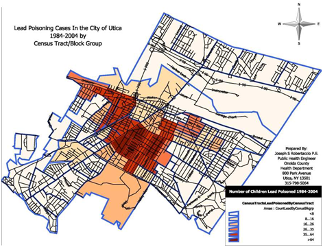
Not only did urban planning lead to the separation of already segregated communities through the creation of freeways. Lead poisoning is also an epidemic faced by African Americans communities in Utica. The effects of lead poisoning on children are extremely harmful, if not fatal, and can result in the inability to comprehend language at a young age, lower IQ, illiteracy, and behavioral issues[1]. Although the use of lead paint in pipes were outlawed in 1978, many of the African American communities are forced to deal with dated infrastructure that allows the effects of lead to still plague their communities. Furthermore, the problem of lead poisoning is a problem faced only by those in the predominately African American communities “Lead poisoning in the city of Utica is concentrated in Cornhill and West Utica, the two neighborhoods that are home to the majority of the city’s low-income minority population.”[2] (See Figure 2)
Continuing west through the heart of New York State, Syracuse is the final city to look into when it comes to how their African American communities were treated. Much like Albany, Utica, and Buffalo, Syracuse used redlining as well as urban planning to segregate and impoverish African Americans. Much like the interstate 790 project in Utica separated white communities from black. Interstate 81 through Syracuse was drawn to do the same. One could argue those who set out to prevent African Americans from generating wealth were quite successful, as Syracuse ranks first in the country in concentrated poverty among Black and Latino Americans.[1] When it came to urban planning and the construction of interstate 81 through the city of Syracuse, rather than being used as a means to divide white and African American communities, it was decided to just steamroll the communities, and force those living there to find new homes. The 15th ward was one of these redlined communities demolished. In a cnyvitals.org article in 2018, the following was stated of the area.11
The 1950s introduced more institutional discrimination. The 1956 Federal Highway Act was a major infrastructure bill meant to connect American cities through a network of highways. While the highways helped make traveling and commuting more efficient and convenient, it also divided American cities on a micro level. Highways were built only within yellow and redlined areas. This was the case in Syracuse upon the construction of Interstate-81 (I-81).
Richard Breeland, a Syracuse resident since he was two years old, lived in the 15th ward of Syracuse. The 15th ward was a hub of diverse racial and ethnic backgrounds. As a redlined neighborhood, it was demolished to construct I-81. Breeland told Kijin Higashibaba of WAER that the 15th ward was a homey, quiet and thriving neighborhood. City officials saw it differently.
“It was called Jew town, it was called the slum area, and it was called the ghetto. Those were the three names that were associated with our community,” Breeland said.11
Although Syracuse may have done a better job in their cities at avoiding the segregation dispute, their hands are not clean when it comes to racism faced by African Americans on a systemic level.
It becomes clear as you look deeper into the history of the challenges faced by the African American community that the struggles they faced were not only faced by those living in the American south, but were shared by African Americans everywhere throughout the country. Whether it was segregation, redlining, gentrification or any other disadvantages thrown at African Americans, they experienced the same hardships wherever they were, and the states of the North are just as guilty of systemic racism as those in the south that they so often criticize.
Bibliography
Bureau, US Census. “Decennial Census of Population and Housing by Decades.” Census.gov, November 24, 2021. https://www.census.gov/programs-surveys/decennial-census/decade.2010.html.html.
Central New York Community Foundation May 18, 2018, 2021 Conor Muldoon December 7, 2021 Central New York Community Foundation October 27, and 2021 Central New York Community Foundation June 7. “How the History of Redlining and I-81 Contributed to Syracuse Poverty: CNY Vitals.” CNY Vitals |, May 18, 2018. https://cnyvitals.org/how-the-history-of-redlining-and-i-81-contributed-to-syracuse-poverty/.
“Interstate 790 New York.” Interstate, February 19, 2019. https://www.interstate-guide.com/i-790-ny/.
Lead, Lana. “The Unspoken Dangers of Urban Development: Lead Poisoning, Ghost Factories and Gentrification.” loveandrage, June 22, 2016. https://loveandragemedia.org/2016/05/11/the-unspoken-dangers-of-urban-development-lead-poisoning-ghost-factories-and-gentrification/.
Maeroff, Gene L. “3 Upstate Cities Exemplify the Busing Dispute.” The New York Times. The New York Times, March 14, 1972. https://www.nytimes.com/1972/03/14/archives/3-upstate-cities-exemplify-the-busing-dispute-3-upstate-cities-face.html.
“Mapping Inequality.” Digital Scholarship Lab. Accessed December 20, 2021. https://dsl.richmond.edu/panorama/redlining/#loc=12/42.659/-73.849&city=albany-ny.
“New York Leads Nation in Number of Segregated Schools: Report .” nydailynews.com, March 26, 2014. https://www.nydailynews.com/new-york/education/new-york-leads-nation-segregated-schools-report-article-1.1735795.
Team, Chronicle Digital. “Why Albany's Black Neighborhoods Are Its Most Economically Challenged.” Times Union. Times Union, June 6, 2021. https://www.timesunion.com/projects/2021/albany-divided/.
[1] Central New York Community Foundation May 18, 2018, 2021 Conor Muldoon December 7, 2021 Central New York Community Foundation October 27, and 2021 Central New York Community Foundation June 7. “How the History of Redlining and I-81 Contributed to Syracuse Poverty: CNY Vitals.” CNY Vitals |, May 18, 2018. https://cnyvitals.org/how-the-history-of-redlining-and-i-81-contributed-to-syracuse-poverty/.
9 Lead, Lana. “The Unspoken Dangers of Urban Development: Lead Poisoning, Ghost Factories and Gentrification.” loveandrage, June 22, 2016. https://loveandragemedia.org/2016/05/11/the-unspoken-dangers-of-urban-development-lead-poisoning-ghost-factories-and-gentrification/.
[2] Lead, Lana. “The Unspoken Dangers of Urban Development: Lead Poisoning, Ghost Factories and Gentrification.” loveandrage, June 22, 2016. https://loveandragemedia.org/2016/05/11/the-unspoken-dangers-of-urban-development-lead-poisoning-ghost-factories-and-gentrification/.
[1] Mapping inequality. Digital Scholarship Lab. (n.d.). Retrieved October 6, 2021, from https://dsl.richmond.edu/panorama/redlining/#loc=12/43.093/-75.306&city=utica-ny.
[1] “Interstate 790 New York.” Interstate, February 19, 2019. https://www.interstate-guide.com/i-790-ny/.
[1] “Mapping Inequality.” Digital Scholarship Lab. Accessed December 20, 2021. https://dsl.richmond.edu/panorama/redlining/#loc=12/42.659/-73.849&city=albany-ny.
[2] Team, Chronicle Digital. “Why Albany's Black Neighborhoods Are Its Most Economically Challenged.” Times Union. Times Union, June 6, 2021. https://www.timesunion.com/projects/2021/albany-divided/.
[3] Team, Chronicle Digital. “Why Albany's Black Neighborhoods Are Its Most Economically Challenged.” Times Union. Times Union, June 6, 2021. https://www.timesunion.com/projects/2021/albany-divided/.
[1] “New York Leads Nation in Number of Segregated Schools: Report .” nydailynews.com, March 26, 2014. https://www.nydailynews.com/new-york/education/new-york-leads-nation-segregated-schools-report-article-1.1735795.
[2] Maeroff, Gene L. “3 Upstate Cities Exemplify the Busing Dispute.” The New York Times. The New York Times, March 14, 1972. https://www.nytimes.com/1972/03/14/archives/3-upstate-cities-exemplify-the-busing-dispute-3-upstate-cities-face.html.
[1] Bureau, US Census. “Decennial Census of Population and Housing by Decades.” Census.gov, November 24, 2021. https://www.census.gov/programs-surveys/decennial-census/decade.2010.html.html.